Trail Snowshoes Autrans-Méaudre en Vercors - Le Gros Martel - Méaudre - Photo
 tracegps
tracegps

User

© OpenStreetMap contributors
Length
Length
4.9 km
Max alt
Max alt
1551 m
Uphill gradient
Uphill gradient
255 m
Km-Effort
Km-Effort  
8.4 km
Min alt
Min alt
1306 m
Downhill gradient
Downhill gradient
257 m
Boucle
Boucle
Yes
Creation date :
2014-12-10 00:00:00.0
Updated on :
2014-12-10 00:00:00.0

(4 Reviews)

Snowshoes
Snowshoes
2h10
Difficulty : Medium

Scan this QR Code to open this trail in the SityTrail application

FREE GPS app for hiking

Logo SityTrail SityTrail

IGN / Geographical institutes

Download SityTrail from the App Store Download SityTrail from Google Play

Logo SityTrail SityTrail World

The world is yours!

Download SityTrail from the App Store Download SityTrail from Google Play Download SityTrail on Huawei AppGallery

About

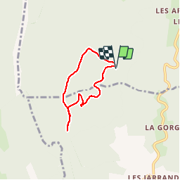
Trail Snowshoes of 4.9 km to be discovered at Auvergne-Rhône-Alpes, Isère, Autrans-Méaudre en Vercors. This trail is proposed by tracegps.

Description

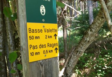
Circuit Raquettes de Méaudre, à effectuer de préférence dans le sens horaire. Départ du Refuge des Narces. Valeurs théoriques de l'OT : 4.5km ;  255m ; 2h10

Elevation profile

Photos

Positioning

Country:
France
Region :
Auvergne-Rhône-Alpes
Department/Province :
Isère
Municipality :
Autrans-Méaudre en Vercors
Location:
Méaudre
Start:(UTM)
697862 ; 4997638 (31T) N.

Comments

Please log in to post a review or rate the element


tb


Samedi du 04/06/22


Trails nearby

Trail Walking Villard-de-Lans - cabane de robon - Photo
Walking
Sylvie Mathiot

Walking

Very easy
(1)
Villard-de-Lans, Auvergne-Rhône-Alpes, Isère, France
10.2 km | 15.8 km-effort
5h 25min
Yes
Trail Walking Villard-de-Lans - Le Plateau du Cornafion 1906m - Photo
Walking
tracegps

Walking

Difficult
(1)
Villard-de-Lans, Auvergne-Rhône-Alpes, Isère, France
7.8 km | 17.7 km-effort
4h 30min
Yes
Trail On foot Rencurel - La Balme Noire par la vire de Haute Valette - Photo
On foot
cmarit

On foot

Difficult
(1)
Rencurel, Auvergne-Rhône-Alpes, Isère, France
10.5 km | 21 km-effort
Unknown
Yes
Trail Mountain bike Villard-de-Lans - Villars de Lans Vières Les Cochettes Balcon de Villard Clot de la Balme Correncon - Photo
Mountain bike
GrouGary

Mountain bike

Medium
(1)
Villard-de-Lans, Auvergne-Rhône-Alpes, Isère, France
22 km | 32 km-effort
3h 31min
Yes
Trail Walking Villard-de-Lans - Gorges de la Bourne - Photo
Walking
flyingdad

Walking

Easy
(5)
Villard-de-Lans, Auvergne-Rhône-Alpes, Isère, France
5.5 km | 8.8 km-effort
2h 13min
Yes
Trail Mountain bike Villard-de-Lans - La Royale (variante) - Photo
Mountain bike
flyingdad

Mountain bike

Medium
(1)
Villard-de-Lans, Auvergne-Rhône-Alpes, Isère, France
28 km | 37 km-effort
4h 0min
Yes
Trail Bicycle tourism Villard-de-Lans - col d'Herbouilly/route des Goulets/Pont en Royans/gorges de la Bourne - Photo
Bicycle tourism
cmarit

Bicycle tourism

Difficult
Villard-de-Lans, Auvergne-Rhône-Alpes, Isère, France
60 km | 86 km-effort
6h 21min
No
Trail Walking Choranche - reco tunnel Arbois  - Photo
Walking
cousam

Walking

Medium
Choranche, Auvergne-Rhône-Alpes, Isère, France
4.4 km | 8.8 km-effort
1h 54min
Yes
Trail Walking Rencurel - 38 vire bourne goule noire  - Photo
Walking
himba26100

Walking

Medium
Rencurel, Auvergne-Rhône-Alpes, Isère, France
11.9 km | 24 km-effort
6h 44min
Yes


Close
My subscriptions